 Chapter 4 – Site Policies
Ashford Urban Area
S3 Court Lodge (2016 Draft / 2017 Main Changes)
This is the first of three of sites in Kingsnorth, not forming extensions to Park Farm, that will increase the built up area to the South of Ashford and will affect traffic passing through South Ashford to the M20 and Town Centre.
The total area of these sites is larger than Park Farm but it is not intended that the development should take place on the whole area. We produced a composite map showing the indicative areas of development as proposed in the 2016 version of the Draft Local Plan. Changes to wording in text accompanying Policy S3 is likely to lead to a change in the areas that are developed.
Changes to Policies S4 and S5 increase the total number of dwellings from 1370 to 1500 on the three sites together with 800 sq.m of retail and employment space and a two form entry primary school.
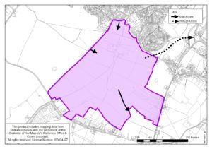
The site lies to the south of Pound Lane, east of Long Length and north of Magpie Hall Road. It is largely flat, arable and grazing land which lies partly within the floodplain of the Whitewater Dyke which passes through the site.
The site is proposed for up to 950 dwellings, although a final site capacity should be determined following a detailed and inclusive site masterplanning exercise that should inform any planning application for development on the site. The built footprint should be on the northern half of the site to enable closer links to the existing development to the north. This will necessitate the remodelling of the Whitewater Dyke’s floodplain to the southern part of the site which in turn should be set out to provide publically accessible open space and ecological mitigation areas, that will form an extension of the Discovery Park.
The built footprint of the development should be established through further discussions with the Environment Agency with the objective of consolidating development on the northern half of the site if possible as this will enable closer links to the existing residential development to the north and providing publically accessible space through an extension to the Discovery Park being formed west of Long Length. If this proves not to be possible, an alternative layout may be considered that keeps the existing floodplain area free from built development but with a more dispersed development footprint. In either circumstance, suitable areas for public open space and ecological mitigation will need to be provided.
To provide a focal point for the community, the development shall also include a ‘local centre’ for the provision of day to day retail services of up to 450 sq.m. This will also need to include land for the provision of a new two form entry primary school to serve the local area, and up to 350 sq.m. of serviced local employment (B1) space. A Community building should also be provided at the local centre.

