1 Summary
This document forms South Ashford Community Forum’s (SACF) response to the Draft Recommendations produced by the Local Government Boundary Commission for England (LGBCE) as part of an Electoral Review of Ashford Borough Council.
SACF objects to the warding proposed for the unparished area of South Ashford as it fails to address the issues identified in its submission to the Consultation on Warding Arrangements (previous submission) and exacerbates the separation of the Watercress area from the rest of the ward.
The LGBCE has failed to acknowledge SACF’s previous submission in its report on the Draft Recommendations.
SACF has reviewed the data used in its previous submission and adjusted the number of voters likely to arise from new development to align with Ashford Borough Council’s Housing Trajectory. Although this gives a reduced electorate, compared with that forecast in the previous submission, it is still considered that the unparished area of South Ashford warrants five full seats in the Council and presents a proposal which resolves the issues identified in the previous submission.
With the exception of Figure 4, the maps we have used have been created using Google Maps. Clicking on the map image will link to the online maps.
2 Draft Recommendations
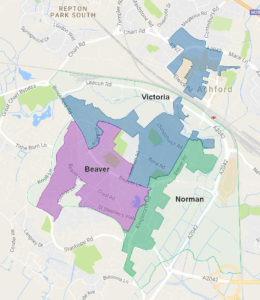
The LGBCE Draft Recommendations for wards for South Ashford are illustrated in Figure 1.
The proposal is based on a submission during the initial consultation by Ashford Borough Council. It retains the existing wards that cover South Ashford with the following differences:
- Recommendations made during the 2015 Community Governance Review in respect of the boundaries between Beaver Ward and the Parish of Great Chart with Singleton and between Norman Ward and the Parish of Kingsnorth have been adopted,
- Arlington, Boxley, Clockhouse and that part of Brookfield Road that was in Victoria Ward will be in Beaver Ward,
- Those parts of Victoria Ward that are north of Somerset Road and New Street will be removed to Stour Ward, renamed Furley Ward,
- The area between Chart Road and the Charing Cross to Ashford railway line have been moved from Godinton Ward to Victoria Ward, and
- A small change to the boundary of Beaver with Norman Ward to bring the whole of the extended Farrow Court into Beaver Ward.
3 Current Ward Boundaries
The comments made in the previous submission are reproduced for clarity:
The shapes of the district council wards that serve the unparished area of South Ashford have long been a concern of South Ashford Community Forum. The proposals put forward in this document seek to rectify the issues created by the shapes of the existing wards, whilst accounting for a likely increase in the electorate.
The Victoria Ward includes the town centre, the Christchurch area and the north-west part of the Brookfield Estate with Watercress.
The Town Centre is separated from the remainder of the Ward by the Charing Cross to Ashford railway line. Whilst the Beaver Road (Station) Bridge lands within the ward to the north and south of the railway, it is a busy dual carriageway and acts more as a division between the communities than a link. The communities of the Brookfield and Watercress estates are physically separated from those of Christchurch area by the open space of Victoria Park and the sites of the Ashford College and South School. The only roads linking the two are Brookfield Road/Beaver Lane that passes through Beaver Ward and Leacon Road / Victoria Road that forms the spine road for the Chart Industrial Estate and does not form a satisfactory community link.
The Norman Ward has a large land area, most of which is undeveloped or comprises commercial development. Two distinct residential communities of Torrington Road and Hampden are separated by industrial / retail estates.
These issues are represented in Figure 3 that shows the wards excluding the areas that have no no dwellings.
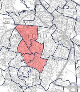
In addition to the topological issues, four of the eight Lower Layer Super Output Areas (indicatedin Figure 4) that make up the unparished area ofSouth Ashford, including those covering Brookfield and Watercress, are among are the 20% most deprived in England (Department for Communities and Local Government, 2015) and therefore have needs very different to those of the town centre.
Inclusion of these topologically and socially disparate areas renders effective representation of the electorate in those areas more difficult for councillors.
4 Comments on Draft Recommendations
The proposal exacerbates problems created by the existing shape of Victoria Ward in that
- a smaller area, hence number of voters, in the Watercress area to the west of Brookfield will be isolated from other parts of the ward,
- a larger area of the ward is north of the Charing Cross to Ashford Railway line, which is likely render effective representation of the electorate in South Ashford more difficult for councillors.

Figure 4 South Ashford LSOAs in 20% most deprived
The proposal makes no substantive change to Norman Ward, hence fails to address the concerns expressed in our previous submission.
4.1 Victoria Ward
The LGBCE’s Report states in respect of Furley and Victoria Wards
“We received two submissions concerning the area of Furley and Victoria, from the Council and a local organisation. The two submissions proposed differing boundaries.
“We are proposing to accept the Council’s scheme in this area as it allows for better electoral equality than the alternative which proposed a significantly higher variance. Both Furley and Victoria are based on the existing wards in this area, with a slight amendment to the boundary between the two. Both wards will have a good level of electoral equality by 2022.”
SACF is aware of three submissions relating to Victoria Ward, ABC’s, one by Central Ashford Community Forum and our own. A similar statement in the Report relating to Beaver and Norman Wards leads us to believe that the SACF submission has been disregarded.
4.1.1 Development
We do not believe that sufficient account has been taken of new development within the proposed Victoria Ward boundaries.
There are four major residential developments currently under way or planned in that part of the proposed Ward that lies north of the Charing Cross to Ashford railway line: Panorama, Trafalgar House, Godinton Way and Elwick Place. Based on the submitted planning applications and the Housing Trajectory included in ABC’s Draft Local Plan (Ashford Borough Council, 2016) these add 520 dwellings to the ward. This does not take into account a number of smaller conversions of commercial premises to residential under way or proposed.
There are three major developments for which planning applications have been submitted within the ward in South Ashford: the Powergen Site, Victoria Way East and the Travis Perkins sites. A further site, Leacon Road, is shown in the Council’s Housing Trajectory as being developed before 2022.
- The Powergen site, for which planning permission has been granted, comprises 660 residential units, however the Housing Trajectory indicates that 250 of these are planned to be complete by 2022. We included the whole of this development in the estimate of the electorate given in our previous submission.
- Victoria Way East, for which planning permission is pending completion of a Section 106 agreement, includes 216 units.
- The Travis Perkins sites for which permission is also pending completion of a Section 106 agreement, comprises 59 units. This site is not included in the Council’s Housing Trajectory.
- Leacon Road is shown in the current and Draft Local Plan as including 100 residential Units.
The total number of dwellings due to be completed by 2022 in these South Ashford, Victoria Ward developments is 625. This excludes small infill developments.
4.1.2 Estimated electorate
| Voters | |
| 2016 Electorate | 3,968 |
| Move to Furley | -360 |
| Move from Godinton | 627 |
| Move to Beaver | -449 |
| Net movements | -182 |
| Net existing electorate | 3,786 |
| Additional from development | 1,968 |
| Forecast Total | 5,754 |
Victoria Ward had 3,968 voters in February 2016. The change in boundaries creates a net reduction of 182 existing voters compared with the existing ward, giving 3,786 existing voters in the ward as proposed in the Draft Recommendations. The Draft Recommendations Report gives the 2022 electorate as 4,103 thus allowing 317 additional voters. From 4.1 above the total number of new dwellings planned is 1145. This implies that the the Draft Recommendations include a provision 0.28 voters for each new dwelling.
The developments in the town centre are mainly flats hence we propose a conservative estimate of 1.5 voters per dwelling this would increase the electorate by 781 voters.
The developments in the South of the Ward are of mixed types and sizes, hence we believe that the number of voters per unit will be similar to the existing in South Ashford at 1.9, hence adding 1187 voters to the ward.
We therefore estimate that 1968 voters arise from new development, giving a total of 5754 (35% above the Borough average).
4.2 Beaver Ward
The LGBCE’s report states that only one submission was made in relation to Beaver and Norman Wards, that being Ashford Borough Council’s again apparently ignoring SACF’s submission.
The proposals move Arlington, Boxley and Clockhouse to the existing ward from Victoria Ward. From data obtained from Ashford Borough Council there were 449 voters in these streets.
The small change at the boundary with the Parish of Great Chart with Singleton moves 9 voters out of the ward.
4.2.1 Development
There is a small change at its boundary with Norman Ward to include the whole of the extended Farrow Court sheltered housing accommodation. This redevelopment will increase the number of occupants. It is understood that Phase 1 of the development was complete and occupied, comprising 33 flats within which there were 26 voters. A further 51 flats were still to be built, from which we estimate an additional 40 voters would be added to the ward.
The Council’s Planning Committee voted to permit the redevelopment of the Ashford College site in Jemmett Road in 2011. This permission was granted in December 2016, when the Section 106 Agreement was signed. The College will move to new premises in September 2017. The developer has indicated that he intends to construct approximately 160 dwellings of mixed size. We estimate that this will add 304 voters to the ward.
Our submission to the Consultation on Warding Arrangements included the site adjacent to the College site, the South School Site. However the Council’s Housing Trajectory shows this as being developed later than 2022.
4.2.2 Estimated Electorate
The Council’s submitted data gives an electorate of 4242 voters in 2016.
There will be a net gain of 440 existing voters, giving a total of 4682 existing voters. 344 voters will be added as a result of development giving a total electorate of 5026, 18% above the borough average.
4.3 Norman Ward
Norman Ward is unaffected by the proposals other than the change to the Boundary with the Parish of Kingsnorth, which does not affect any existing or planned voters, and the small change to the boundary with Beaver Ward.
4.3.1 Development
The only substantial planned residential development in the Ward is 38 dwellings on the site of Concorde House, Austin Road, which could add 72 voters to the Ward.
4.3.2 Estimated Electorate
The electorate will increase from 2074 in 2016 to 2146 in 2022, less than 1% variance.
5 Proposal for Ward Boundaries in South Ashford
Table 2 Current Electorate |
||
| Ward | Voters | |
| Beaver | 4035 | |
| Norman | 1989 | |
| Victoria | 3781 | |
| Total inc Town Centre | 9814 | |
| exc Town Centre | * 8962 | |
| * Excludes 9 voters in Lodge Close and The Burrows | ||
Table 3 Forecast electorate |
||
| Voters | ||
| Existing | 8962 | |
| Leacon Way | 190 | |
| Powergen (250 dwellings / 660) | 477 | |
| Victoria Way | 429 | |
| College | 303 | |
| Concorde House | 38 | |
| Total | 10537 | |
Table 4 Electorate in proposed wards |
||
| Proposed Ward | Electorate | Variance to Borough Average |
| Brookfield | 4309 | 1.4% |
| Christchurch | 4001 | -5.9% |
| Woolreeds | 2218 | 4.4% |
| The calculation of the electorate in each ward is given in Appendix 1 | ||
Taking into account the development identified in 4 above the total electorate in the unparished area of South Ashford will be 10528 in 2022 less than 1% below the average for five councillors.
Whilst we would prefer that single seat wards were used we have been unable to identify suitable ward boundaries to create five single seat wards. It is therefore proposed that three wards are created, two of two seats and one of one seat.
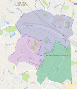
Ward boundaries are arranged to, as far as is practical, resolve the issues raised regarding the existing wards. The proposed wards are shown in Figure 5.
The wards proposed are compact, with good road links within the wards, thus assisting effective representation.
6 Central Ashford Wards
SACF has not carried out a detailed analysis of the changes to the Central Ashford wards, other than the impact of development and proposed changes and development on the Central Ashford part of Victoria Ward detailed in 4.1 above. From that analysis the electorate in the north part of the Victoria Ward as proposed in the Draft Recommendations will be 1,917. That in the proposed Furley Ward will be 4,628. Summing these figures gives a total of 6,364. This is equivalent to 11 voters below the proposed average for three councillors. The size of the town centre ward could be balanced to a single seat ward by reinstating all or part of the area moved to Furley Ward in the Draft Recommendations.
7 Conclusion
South Ashford Community Forum proposes that
- the unparished area of South Ashford is represented by five councillors serving two, two seat wards and one single seat wards as illustrated in Figure 6.
- the district ward boundary at Knoll Lane runs along the centre of Knoll Lane and the boundaries of the adjacent wards intersect with it at the junction of Knoll Lane and Cuckoo Lane,
- the boundary of district wards to the south of the unparished area is aligned to be coterminous with the boundary of the Parish of Kingsnorth.
The proposal will create the need for an extra seat on the Council.
8 Bibliography
Ashford Borough Council. (2016). Draft Local Plan – Regulation 19 Version. Ashford, Kent.
Department for Communities and Local Government. (2015). The English Indices of Deprivation 2015. London.
9 South Ashford Community Forum
South Ashford Community Forum is an open forum set up to represent the views of people living and working in the unparished area of South Ashford and to help communicate those views to Ashford Borough Council, Kent County Council and other statutory organisations.The area represented by South Ashford Community Forum comprises the whole of the current Beaver and Norman district council wards and that part of Victoria Ward that lies to the South of the Charing Cross to Dover railway line


