Preamble
This is the online version of the South Ashford Community Forum submission to the Local Government Boundary Commission for England’s (LGBCE) consultation on warding arrangements.
The LGBCE is the independent organisation that provides electoral arrangements for English local authorities that are fair for voters and keeps the map of English local government in good repair.
The consultation is the first part of an electoral review which will re-draw ward boundaries across the borough.
The Commission has also announced that it is minded to recommend that the council should have 47 borough councillors in the future: four more than the current arrangements.
The Commission now needs information from people and groups across Ashford to help it to produce a new pattern of wards to accommodate 47 councillors.
We have tried to comply with the LGBCE’s main criteria when setting out these proposals. They are:
- The new pattern of wards should mean that each councillor represents roughly the same number of voters as elected members elsewhere in the authority.
- Ward patterns should – as far as possible – reflect community interests and identities and boundaries should be identifiable.
- The electoral arrangements should promote effective and convenient local government and reflect the electoral cycle of the council.
More information is available in the LGBCE’s document How to propose a pattern of wards and their Technical Guidance
You are welcome to make comments on our proposals using the form below. We would like to know, especially, what your thoughts on
- the ward boundaries we have proposed as shown in Figure 6.
- the names of the wards we have suggested
You can open any of the maps in Google Maps by clicking on the image in this document. They will open in a new tab in your browser.
The LGBCE consultation information is available on the LGBCE website
1 Introduction
South Ashford Community Forum is an open forum set up by Ashford Borough Council to represent the views of people living and working in the unparished area of South Ashford and to help communicate those views to Ashford Borough Council, Kent County Council and other statutory organisations.
The area represented by South Ashford Community Forum comprises the whole of the current Beaver and Norman district council wards and that part of Victoria Ward that lies to the South of the Charing Cross to Dover railway line.
With the exception of Figure 3, the maps we have used have been created using Google Maps. Clicking on them will open the online maps.
2 Current Ward Boundaries
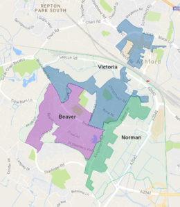
The shapes of the district council wards that serve the unparished area of South Ashford have long been a concern of South Ashford Community Forum. The proposals put forward in this document seek to rectify the issues created by the shapes of the existing wards, whilst accounting for a likely increase in the electorate.
The Victoria Ward includes the town centre, the Christchurch area and the north-west part of the Brookfield Estate with Watercress
The Town Centre is separated from the remainder of the Ward by the Charing Cross to Ashford railway line. Whilst the Beaver Road (Station) Bridge lands within the ward to the north and south of the railway, it is a busy dual carriageway and acts more as a division between the communities than a link. The communities of the Brookfield and Watercress estates are physically separated from those of Christchurch area by the open space of Victoria Park and the sites of the Ashford College and South School. The only roads linking the two are Brookfield Road/Beaver Lane that passes through Beaver Ward and Leacon Road / Victoria Road that forms the spine road for the Chart Industrial Estate and does not form a satisfactory community link.
The Norman Ward has a large land area, most of which is undeveloped or comprises commercial development. Two distinct residential communities of Torrington Road and Hampden are separated by industrial / retail estates.
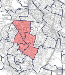
These issues are represented in Figure 2 that shows the wards excluding the areas that have no dwellings.
In addition to the topological issues, four of the eight Lower Layer Super Output Areas (indicated in Figure 3) that make up the unparished area of South Ashford, including those covering Brookfield and Watercress, are among are the 20% most deprived in England (Department for Communities and Local Government, 2015) and therefore have needs very different to those of the town centre.
Inclusion of these topologically and socially disparate areas renders effective representation of the electorate in those areas more difficult for councillors.
-

-
Figure 2 Current ward boundaries
-
-
Figure 3 Current ward residential areas
-
-
Figure 3 South Ashford LSOAs in 20% most deprived
3 Community Governance Review
During 2015 Ashford Borough Council carried out a Community Governance Review.
A proposal to parish the South Ashford Community Forum area was proposed but not carried to the final recommendations because the result of a ballot was negative. The Community Forum therefore remains the only form of Community Governance for the area.
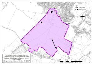
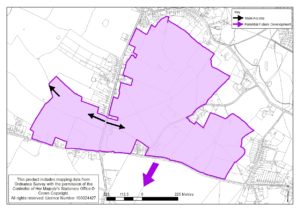
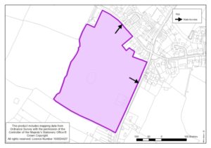
Two changes were recommended to boundaries of parishes bordering the unparished area of South Ashford. These changes were:
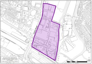
- The south-east boundary of the Parish of Great Chart with Singleton Parish with Beaver Ward be amended to include 16 & 17 Lodge Close and 1-10 The Burrows within the Parish. These properties are currently within the un-parished urban area. This amendment is shown on Plan 4 in Appendix 1.
We propose that the district ward boundaries are adjusted to be coterminous with the boundary of Great Chart with Singleton.
We further propose that the district ward boundary continues along the centre of Knoll Lane and, assuming that a ward boundary along Cuckoo Lane is retained, that the intersection of the three wards occurs in the centre of the junction of Knoll Lane and Cuckoo Lane, moving the boundary to the road. No properties will be affected, but it moves the boundary to the road, which is a sensible recognised boundary feature.
- The boundary of the Parish of Kingsnorth with the boundary of the South Willesborough [and Norman], Ward[s] as shown on Plan 10 in Appendix 1. No properties are affected, but it moves the boundary to the road, which is a sensible recognised boundary feature.
We propose that the district ward boundary is amended to be coterminous with the boundary of the Parish of Kingsnorth.
4 Proposed development in South Ashford
Whilst there has been much residential development in the parishes that border South Ashford since the last Electoral Review, there has been little in the unparished area of South Ashford. In the last year however, schemes have come forward that will have an impact on the number of residential properties in South Ashford, hence the number of voters.
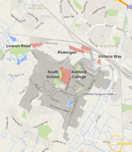
Figure 4 Proposed Development
The following proposals have been considered:
4.1 Powergen Site
This proposed development will utilise derelict land once occupied by the Ashford’s electricity generating station, now lying either side of Victoria Road and Leacon Road. It was granted planning permission by Ashford Borough Council on 15th June 2016. The developer has commenced detailed surveys and clearing the site.
A total of 660 dwellings are proposed, housing approximately 2000 residents.
4.2 Victoria Way
Developer U+I has held a number of public consultation events and has attended a South Ashford Community Forum Meeting to present information on this mixed use development that will use derelict land at the junction of Beaver Road and Victoria Road.
A planning application submitted by the U+I subsidiary, HDD Ashford, has been verified by the Council, which includes 216 dwellings. News releases by the proposed occupier indicate that funding is in place for some of the non-residential elements of the development, giving a strong indication that this development will proceed if permission is granted.
4.3 Ashford College Site
A new campus is being constructed, in the Town Centre, for Ashford College. Its current site will become vacant in September 2017 when the College moves to its new campus.
The current and draft Local Plans allocate the site for housing development. An outline planning application was submitted in 2007 for 241 dwellings on the site. The application was approved but with a condition that no more than 154 dwellings were built, unless the applicant could show that more could be accommodated whilst complying with all of the Council’s policies. The Council have included the lower number in their Housing Trajectory for the Draft Local Plan.
4.4 South School Site
This site was vacated by the LEA some years ago and has been used for various purposes temporarily since then. Development of the site has been inhibited by lack of suitable access, which will be enabled by the development of the adjacent College site. The site is now in use as a as a temporary accommodation for Finberry Primary School which we understand will end in September 2017, coinciding with the College site becoming vacant.
The Draft Local Plan proposes 110 dwellings on the site.
4.5 Leacon Road
This site now comprises two plots, both of which were industrial uses. The smaller plot is included in the current Local Development Framework as site U7 and is allocated for residential development of 100 units. This allocation has been carried forward in the Council’s Draft Local Plan.
5 Forecast Electorate for South Ashford
We have calculated the future electorate in South Ashford using the number of voters from data provided by Ashford Borough Council for 1st April 2016 together with an estimate of the number voters that will reside in the major developments that are detailed in 4 above. We have assumed that the number of voters in the new developments will be equivalent to the current number of voters per residential address. We believe this offers a more accurate forecast of electorate than the data included in the Review documentation.
Table 1 Current Electorate
| Ward |
Voters |
| Beaver |
4035 |
| Norman |
1989 |
| Victoria |
3781 |
| Total inc Town Centre |
9814 |
| exc Town Centre * |
8962 |
* Excludes 9 voters in The Lodge and The Burrows
Table 2 Forecast electorate
|
Voters |
| Existing |
8962 |
| Leacon Way |
190 |
| Powergen |
1259 |
| Victoria Way |
429 |
| College |
293 |
| South School |
301 |
| Total |
11342 |
6 Warding
6.1 Council Size
Ashford Borough Council has proposed an increase in the size of the Council to serve a forecast increase in the electorate. The electorate at the time of the Council’s review was 89,862 voters who were represented by 43 councillors, equivalent to 2,090 voters per councillor.
They forecast 99,868 voters in 2022 and propose 47 councillors, which equates to 2,125 voters per councillor.
South Ashford Community Forum supports this proposal.
6.2 Number of Councillors
Based on the Council’s proposal and our forecast of the electorate in South Ashford, five councillors would be required to serve the unparished area of South Ashford with each councillor representing 2268 voters, which will be 6.7% above the proposed average for the Borough.
6.3 Communities
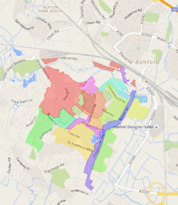
Figure 5 South Ashford Communities
We have attempted to identify the communities that form South Ashford. We have concluded that the communities are derived generally from the development that has created the area. There are dwellings, along the older spine roads of Beaver Road, Kingsnorth Road and Beaver Lane that do not necessarily form part of the developmental communities but may have been assimilated into the communities either side of the roads, sometimes helping to link the communities. The communities identified are shown in Figure 5.
6.4 Ward boundary proposal
We believe that having district wards boundaries aligned to parish boundaries avoids potential confusion among voters and aids effective representation. The latter is also the case for community forum areas in the unparished areas of Ashford, the boundaries of which follow recognisable physical features. We have therefore considered only the area represented by South Ashford Community Forum.
We have reviewed a number of options for dividing the area into wards. Our best fit division is illustrated in Figure 6.
The proposal does not reflect the identities of the local communities as well as we would like. The main discrepancies being
- the split of the Brookfield Estate into two, but this has been achieved by using Brookfield Road as the boundary of the ward we have referred to as Beaver Green,
- the inclusion of that Part of Beaver Road to the north of its junction with Christchurch Road in Station Ward, whereas it might fall more naturally in Christchurch Ward.
Arrangements we have examined that do not introduce these discrepancies either increase the variance between individual ward sizes and the borough average or create other problems in relation to connections within and between communities that are included in the wards.
We have considered creating two seat wards, as currently exist, to eliminate the discrepancies identified but Councillors have informed us that it is more difficult to provide effective representation to multi-seat wards, even where that does eliminate boundaries that cross communities. We have therefore based our proposal on single seat wards.
This proposal gives a maximum variation from the Borough average ward electorate of 7.6% when proposed development has been occupied.
Table 3 Electorate in proposed wards
| Proposed Ward |
Electorate |
Variation /
Borough Average |
|
|
% |
| Beaver Green |
2269 |
6.8% |
| Christchurch |
2256 |
6.2% |
| Watercress |
2260 |
6.4% |
| Station |
2271 |
6.9% |
| Woolreeds |
2286 |
7.6% |

Figure 6 Proposed ward boundaries
The calculation of the electorate in each ward is given in Appendix 2
The wards proposed are compact, with good road links within the wards, thus assisting effective representation.
7 Conclusion
South Ashford Community Forum proposes that
- the unparished area of South Ashford is represented by five councillors each serving single seat wards as illustrated in Figure 6.
- the district ward boundary at Knoll Lane runs along the centre of Knoll Lane and the boundaries of the adjacent wards intersect with it at the junction of Knoll Lane and Cuckoo Lane,
- the boundary of district wards to the south of the unparished area is aligned to be coterminous with the boundary of the Parish of Kingsnorth.
8 Bibliography
Department for Communities and Local Government. (2015). The English Indices of Deprivation 2015. London.
Appendix 1 Community Governance Review Plans
Appendix 2
Click here to download Appendix 2 (pdf)
The complete document can also been downloaded as pdf (2.5 MB)


